As Dennis House of WFSB-TV reminds us, today marks the 80th anniversary of the day an historically destructive hurricane began ripping through Connecticut, including Hartford.
As Dennis House of WFSB-TV reminds us, today marks the 80th anniversary of the day an historically destructive hurricane began ripping through Connecticut, including Hartford.
CT Humanities, through its Connecticut history website, offers a nice summary and list of resources on the hurricane, and the Hartford Courant published this look back in 1999. For video, there’s the 1997 Connecticut Public Television documentary “When Disaster Struck Connecticut,” which looks at four historic weather disasters, including the ’38 hurricane. You can watch it in segments on YouTube.
The hurricane caused massive flooding of the Connecticut River on Hartford’s low-lying East Side, long an immigrant neighborhood. Glenn Weaver noted in his “Hartford: An Illustrated History of Connecticut’s Capital” that residents and merchants there were still recovering from the spring flooding of 1936, which had claimed five lives and still ranks as the worst flood in city history.
“In 1938,” Weaver wrote, “Nature struck again, with the most severe hurricane in the city’s history. On September 21 at 4 p.m., the hurricane struck with full force, leaving the city a shambles: streets blocked by fallen trees and utility polls, crushed automobiles, stranded trolley cars, and debris from hundreds of destroyed or damaged buildings.” Employees of the city and the Works Progress Administration, a federal program that gave work to people left jobless by the still-lingering Great Depression, joined college students and other volunteers in filling and stacking 50-pound bags of sand to reinforce the straining dikes. Around 5:30 p.m. on Friday, September 2, the river reached 35.1 feet above normal; it stayed there until 10 p.m., then slowly began to recede.
The most vivid and detailed account, though, may belong to William Manchester, in his epic 1974 social history “The Glory and the Dream: A Narrative History of America, 1932-1972.” Manchester had lived through the hurricane as a teenager in Springfield, but he relied on oodles of research to describe the destruction that convulsed all of New England and New York. (Nearly as great as the destruction was the shock; New England hadn’t experienced a hurricane since 1815, and the poor state of weather forecasting at the time resulted in almost no one seeing this one coming.)
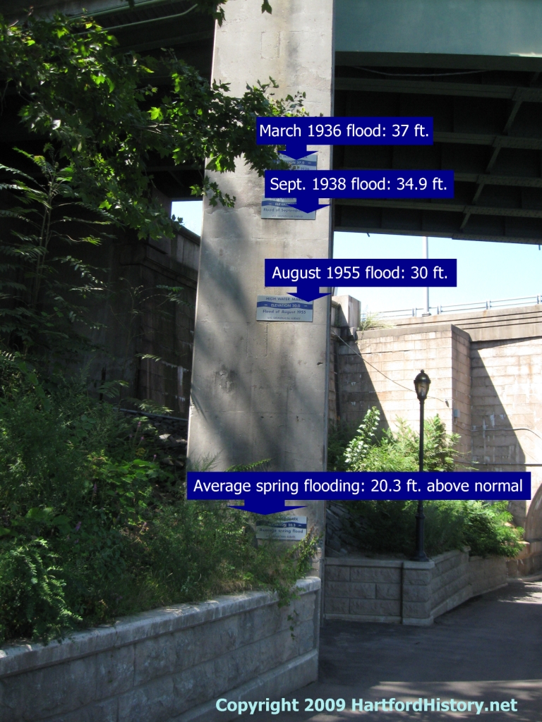
Finally, I couldn’t pass up an opportunity to re-post one of my favorite photos, taken in Hartford’s Riverside Park, on the path along the Connecticut River. The plaques on the pillar indicate the high-water marks for the 1936, 1938, and 1955 floods. The river is out of the frame, to the right, and down an embankment. It makes you thankful for the new and much bigger system of dikes that were already in the planning stages in 1938 and completed in the early 1940s.