Skip to content

Hartford History news blog

News about the history of Connecticut's capital city. A companion to HartfordHistory.net

  • Home
  • About
  • Articles & Images
  • News Blog
  • Trivia Questions
  • Books
  • Other Sites
  • Home
  • About
  • Articles & Images
  • News Blog
  • Trivia Questions
  • Books
  • Other Sites
Hartford History news blog

Tag: maps

A Map of Hartford, Before the Interstate Highways

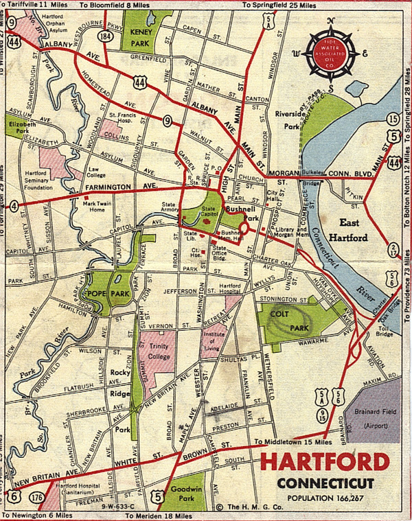
It was probably sometime in the 1940s or early-to-mid-1950s that the Tidewater Associated Oil Co. offered this map of the city. For my rationale on the dating, along with a full-size version of the map, go here.

Author Kevin FloodPosted on May 5, 2020May 5, 2020Tags maps, Redevelopment

Recent Posts

  • Moving right along…
  • Nov. 17: ‘Building Jewish Hartford’
  • Listen to the 2022 Stowe Prize winner
  • About that John Mason statue…
  • Perhaps a reward after all for help in solving 1953 murder

Search the blog

Archives

Tag Cloud

  • Art
  • Books
  • Cemeteries
  • Charter Oak
  • Charter Oak Neighborhood
  • Circus Fire
  • Civil Rights
  • Downtown
  • East Side
  • events
  • Famous people
  • Frog Hollow
  • Getting Around
  • Historic Sites
  • houses of worship
  • Insurance industry
  • labor history
  • Libraries
  • maps
  • Military
  • Monuments and Statues
  • museums
  • natural disasters
  • Newspapers & Magazines
  • Noah Webster
  • Nonprofits
  • North End
  • obituaries
  • podcasts
  • Politics
  • public safety
  • Racial & Ethnic History
  • Radio & Television
  • Redevelopment
  • Resources
  • riverfront
  • riverside park
  • Samuel Colt
  • Sports
  • street names
  • technology
  • tourism
  • Trivia questions
  • Video tours
  • West Hartford
  • Home
  • About
  • Articles & Images
  • News Blog
  • Trivia Questions
  • Books
  • Other Sites
  • Home
  • About
  • Articles & Images
  • News Blog
  • Trivia Questions
  • Books
  • Other Sites
Hartford History news blog Proudly powered by WordPress